- Roundabout replaces signals at confusing intersection.
- The Capitol Promenade gently slopes down from Asylum Hill toward the foot of Capitol Hill. It covers I-84 and the railroad tracks.
- Park River meanders through Bushnell Park.
- New streets break up the block. Frederick Law Olmsted Way, lined with residential, offers a finishing touch to the western edge of the park.
- State Armory and Legislative Building are integrated with park.
SCENE 1
SCENE 2
SCENE 3
The links above lead to images that change from recent photos to superimposed conceptions by moving the curser over text. It may not work on all systems. All the individual images can be viewed by clicking here.
 |
Observations
I-84, exit 48
Exit 48 has become a dual-pronged exit with ramps to Capitol Avenue and Asylum Street. This is due to the poor street pattern on the western side of downtown. For example, it takes some circumnavigation to get from Capitol Avenue to Asylum Street. How about trading in a couple of ramps and let the traffic dissipate on an improved street pattern?
Asylum Street
Asylum Street is the main gateway between Downtown and the Asylum Hill / West End neighborhoods. About midway between the Connecticut River and Mark Twain House, the street begins its incline up to Asylum Hill. At this point, Asylum Street is equidistant from three distinct business districts, Downtown, The Capitol Area and the insurance companies of Asylum Hill.
The last paragraph may lead one to believe that this could be the posh area of town. But no. This is "No Man's Land". Asylum Street serves as a highway access road. The highway and railroad bridges break the continuity here. The sidewalks are narrow. Chain link fences hold back wild brush. The slope of Asylum Hill could be a beautiful setting if not misconstrued as a buffer.
Bushnell Park
The west side of Bushnell Park is up against a wall. There is a sense of incompleteness here that prevents Bushnell Park from being the centerpiece that it could be. Great open spaces should lead somewhere. To encourage pedestrian circulation and growth, this wall needs to be overcome.
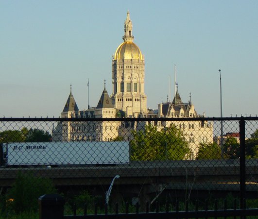
Connecticut's State Capitol building is considered to be among the most beautiful in the country. However, it is detached from much of the surrounding area, which gives the feeling of a long stalled construction project. Connecticut should seriously consider beautifying the Capitol area of its Capital City.
The State Capitol
The Park River
The streets around the north side of Bushnell Park were influenced by the Park River. Today, the river runs straight as an arrow through conduits on the southern side of the park. An alternate (exposed) route can split off at the western side of Bushnell Park near the Armory. It could merge with the conduit again near Pulaski Circle at the southeastern side of the park. Used in conjunction with the conduit, the flow can be regulated or even filtered if needed.
Legislative Building, State Armory and parking garage
The Legislative Building and The State Armory are cut off from Bushnell Park and the rest of the Capitol area. The courtyard between the building and garage leads to an embankment. Perhaps after some buildable area becomes available, the garage could be replaced by an extention of Bushnell Park atop underground parking.
| Existing Highway | 
|
| New Highway | 
|
| Streets | 
|
| Railroad Tracks | 
|
| Existing Buildings | 
|
| New Building Sites | 
|
Can incremental steps be part of a bold plan?
| Asylum Hill | 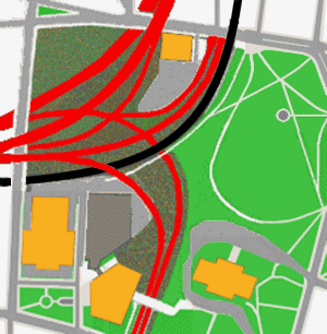
| Downtown |
|---|---|---|
| Frog Hollow | Capitol Area | South Downtown |
Related Articles | ||
|---|---|---|
| "Tunnel Vision For City" | Tom Condon | Hartford Courant, May 12, 2003 |
| "Reclaiming Hartford's No Man's Land" | Bill Mocarsky | Hartford Courant, February 22, 2004 |
| "When The Site Is The Problem" | Toni Gold | Hartford Courant, January 29, 2006 |